
DJI Matrice 300 RTK Enterprise Care Basic - 1 Year Bundle - Includes 2 Flight Batteries and Battery Station
DJI Matrice 300 RTK Enterprise Care Basic - 1 Year Bundle - Includes 2 Flight Batteries and Battery Station
Description
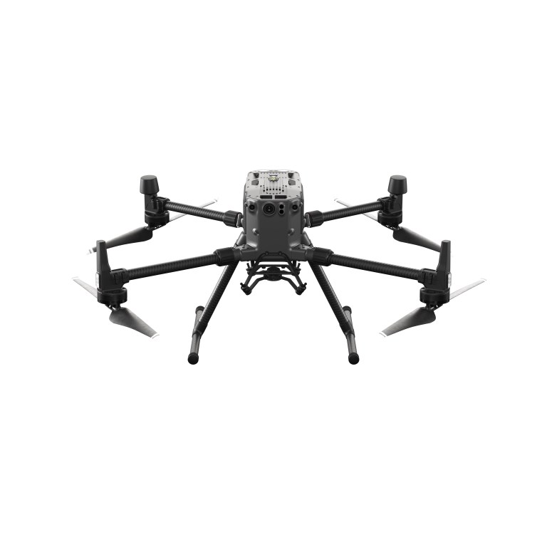
DJI Matrice 300 RTK Survey & Mapping Bundle with BS60 Battery Station, TB60 Batteries & 1-Year Enterprise Care Basic
Take your surveying, mapping, and engineering workflows to new heights with the DJI Matrice 300 RTK (M300 RTK)—a rugged, professional-grade UAV engineered for accuracy, reliability, and long-range performance. This complete bundle equips field teams with everything needed for extended missions, including the BS60 battery station, two TB60 flight batteries, and 1 Year Enterprise Care Basic for enhanced operational peace of mind.
Designed for demanding environments, the M300 RTK excels in topographic data collection, utility inspections, LiDAR workflows, construction progress mapping, mining surveys, and precision agriculture analytics. With advanced obstacle avoidance, centimeter-level real-time kinematic positioning, and compatibility with industry-leading sensors (including the Zenmuse L1, P1, H20 Series), this platform is built for professionals who require accuracy and efficiency in every flight.
What’s Included
- DJI Matrice 300 RTK Aircraft
- BS60 Intelligent Battery Station
- Two (2) TB60 Intelligent Flight Batteries
- 1-Year DJI Enterprise Care Basic
- Standard accessories, charging components & required hardware
Key Features
Engineered for Surveying, Mapping & Engineering
- Centimeter-Level Accuracy with RTK
Achieve survey-grade results for photogrammetry, terrain modeling, volume calculations, and LiDAR workflows with built-in multi-constellation RTK positioning. - Long-Endurance Flight for Large-Area Coverage
Paired with TB60 batteries, the M300 RTK offers long flight times to support corridor mapping, large site documentation, and high-efficiency data capture. - Multi-Payload Support
Compatible with a wide range of sensors including the DJI Zenmuse L2 or L1 (LiDAR), P1 (full-frame photogrammetry), H20/H20T (inspection & mapping)—ideal for engineering, utilities, mining, and geospatial professionals. - Advanced Obstacle Avoidance & Redundancy Systems
Six-directional sensing, dual IMUs, redundant flight systems, and robust fault-tolerance ensure reliable operation in challenging industrial and remote environments. - Rugged for Harsh Survey Conditions
IP45 rating allows deployment in rain, dust, and extreme temperature ranges—suitable for construction sites, open-pit mines, agricultural fields, and rural topographic surveys.
Optimized for Mining & Precision Agriculture
- High-Accuracy Terrain & Volume Measurements
Seamless integration with LiDAR and high-resolution RGB payloads enables accurate stockpile volumes, pit wall mapping, and site change detection. - Efficient Field Mapping & Crop Insights
Capture multispectral or high-resolution imagery (with compatible payloads) for agricultural analysis, field variability, drainage assessment, and planning.
BS60 Battery Station & TB60 Battery Advantages
- Smart Fleet Power Management
The BS60 charges and manages up to eight batteries (TB60/TB30), enabling rapid turnaround for multi-flight survey missions. - TB60 Extended-Life Batteries
Hot-swappable battery technology allows continuous data collection without shutting down the aircraft—ideal for large mapping blocks.
Enterprise Care Basic (1-Year)
- Coverage for accidental damage, including:
- Collisions
- Water damage
- Drop impact
- Sensor or gimbal damage
- Ensures minimal downtime and predictable maintenance for professional operations.
Specifications
- BrandDJI Enterprise
- Product TypeDrone
- Drone TypeMulti-rotor
- Flight Speed23 m/s
- Infrared Thermal Camera Built InN/A
- IP RatingIP45
- Maximum Flight55 minutes
- NIR Auxiliary Light Built InN/A
- Operating Temperature-20°C to 50°C (-4°F to 122° F)
- Payload Capacity2.7 kg
- RTK CapabilityRTK Onboard
- RTK Positioning Accuracy1 cm + 1 ppm (Horizontal), 1.5 cm + 1 ppm (Vertical)
- Warranty1 year