DJI Zenmuse L3
DJI’s Most Advanced Aerial LiDAR and Mapping Payload
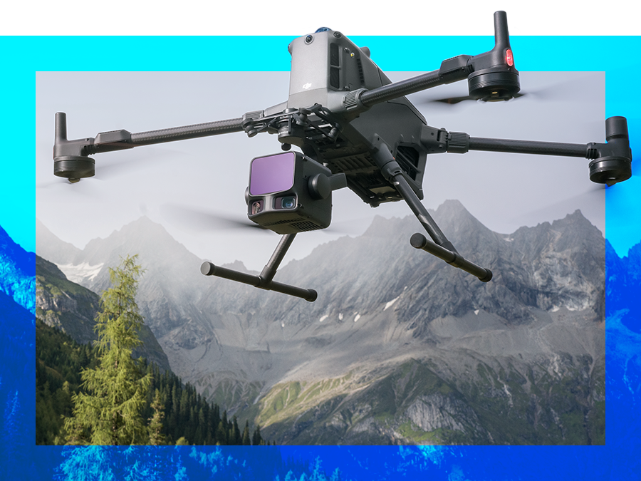
With superior accuracy and extended range, the Zenmuse L3 is DJI Enterprise’s new flagship payload, engineered to transform the way aerial mapping is done. Distance and precision are taken to the next level, as its 1535 nm long-range LiDAR[1] can reach up to 950 m, even on surfaces with just 10% reflectivity, capturing details others can’t and penetrating complex terrain with ease.
Paired with DJI Matrice 400, the L3 turns every flight into a powerhouse of data collection. Surveyors can capture high-density, survey-grade point clouds and photogrammetry-level imagery across vast areas up to 100 km² per day[2].
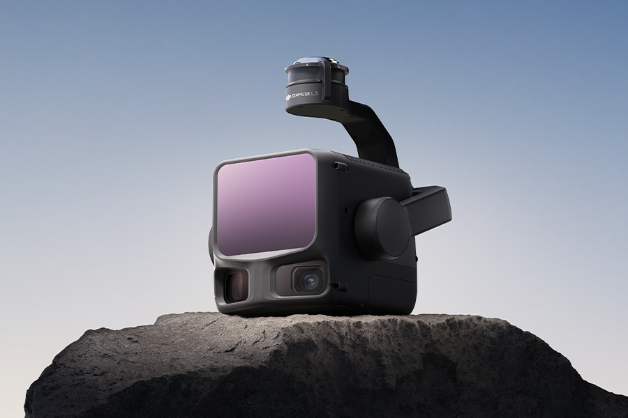
Integrated Dual 100 MP Cameras
Equipped with the dual 100 MP 4/3 CMOS RGB sensors and a mechanical shutter, Zenmuse L3 delivers significantly enhanced accuracy. Pixel binning produces an effective 24 MP resolution with larger pixels for richer color and detail. The dual cameras offer a 107° horizontal FOV, enabling wider coverage per capture. Even with just 20% LiDAR side overlap, users can generate digital ortho maps (DOM) and digital elevation models (DEM) in a single flight—maximizing operational efficiency.
1535 nm Long-Range LiDAR
The Zenmuse L3 delivers up to 950 m detection range with adjustable pulse rates for optimal performance across varying conditions. Its 0.25 mrad beam divergence produces a smaller, more focused laser spot—five times finer than the L2—capturing details like power lines and branches while improving ground point density through vegetation.
Efficiency Boost for Large-Scale Surveys
Its improved IMU allows higher, faster, and longer flights without sacrificing data quality, while 16 LiDAR returns[4] ensure better vegetation penetration and detailed terrain capture, surpassing the performance of its predecessors. Increased coverage reduces flight time, ensures consistent point density, and lowers operational costs, making large-area surveys faster and more efficient.
Reliable and Up for the Challenge
The system features a self-heating IMU, three-axis stabilization, and IP54 protection, ensuring consistent performance even in challenging conditions. Fully compatible with the DJI Matrice 400 RTK, it forms a calibrated, ready-to-use platform for professional surveying missions.
Versatile Applications Across Industries
The L3 provides precise, dense data for geomatics, forestry, mining, civil engineering, urban planning, and heritage conservation. Its LiDAR and RGB integration reduces flight requirements while delivering accurate terrain, vegetation, and structural information for better decision-making and project planning.
Sample Dataset Available
To see is to believe! Explore data files that showcase the remarkable precision and incredible detail captured by the powerful Zenmuse L3 LiDAR.
Access the dataset from an actual test project and watch a highly informative webinar that highlights the capabilities of DJI’s next-generation flagship payload.
Key Features and Performance Highlights

1535 nm Long- Range LiDAR
- Laser Wavelength: 1535 nm.
- Maximum Detection Range: 950 m (center), 650 m (edge) @10% reflectivity.
- Maximum Scanning FOV: 80°×80°.
- Laser Beam Divergence: 0.25 mrad (1/e²).
- Ranging Accuracy: Absolute accuracy ±10 mm, repeatability < 5 mm (1σ), at 300 m with 80% reflectivity[5].

Dual 100 MP RGB Mapping Camera System
- Horizontal FOV: 107°.
- Dual 4/3 CMOS RGB Mapping Cameras: Support 100 MP or 25 MP resolution.
- Minimum Photo Interval: 0.5 s (25 MP), 1 s (100 MP).

High Accuracy
- Vertical Accuracy: 3 cm, Horizontal Accuracy: 4 cm (at 120 m).
- Vertical Accuracy: 5 cm, Horizontal Accuracy: 7.5 cm (at 300 m).
- High-Precision POS System: Yaw Accuracy: 0.02°, Pitch/Roll.
- Accuracy: 0.01° (RMS 1σ, post-processed).

High Penetration
- Superior penetration through vegetation and complex terrain.
- Star-shaped scanning mode for optimal balance of precision and coverage.
- Adjustable laser pulse emission energy.
- Supports up to 16 returns[4].

Up to 100 km² per Day
- Single-flight coverage area up to 10 km2 at a typical operational altitude of 300 m (nadir).
- Daily coverage[2] area up to 100 km² at a typical operational altitude[3] of 300 m (nadir).
- DEM and DOM generation in a single flight.

End-To-End Solution
- Data acquisition, processing, and application covered.
- LiDAR and RGB fusion-based 3D reconstruction.
- Gaussian Splatting for LiDAR reconstruction.
- Point cloud semantic segmentation.
- Supports multiple output formats, including DEM, TIN, grids of points, and contours.
Power Your Missions with the Zenmuse L3 on the Matrice 400

DJI Matrice 400 (M400) with Enterprise Care Plus 1 Year Warranty Auto-Activated and RC Plus 2
Model #CB.202505213091
DJI Matrice 400 (M400) with DJI Care Plus 1 Year Warranty Bundle - Includes 1 Flight Battery + Charger + RC Plus 2
Model #902508
-
- Range Definition: The range is defined as the distance at which 50% of the emitted laser pulses are detected. If a laser beam hits more than one subject, the total laser transmitter power is split and the achievable range is reduced.
- Test Conditions: 100 klx ambient light, within the central area of the FOV, using a flat subject with a size larger than the laser beam diameter, a perpendicular angle of incidence, and an atmospheric visibility of 23 km.
- The maximum detection range is 900 m by default. For a longer range, contact DJI support or an authorized dealer.
- When paired with DJI Matrice 400, Zenmuse L3 can achieve a daily mapping coverage of up to 100 km² (flat terrain, 300m nadir flight altitude, 20% side overlap, 17m/s flight speed, and a total effective flight time of 6 hours).
- The flying altitude limit varies in different countries or regions. Make sure to fly at the altitudes outlined by local laws and regulations.
- Support for 16 returns is limited to laser pulse emission frequency of 100 kHz and 350 kHz.
- Tested at 150 m under ambient temperature of 25° C (77° F) and 80% object reflectivity. Actual results may vary depending on environmental and operational conditions. Data is provided for reference only.
Still have questions?