Map It Your Way
with the new RD8200SG Survey Grade Locator
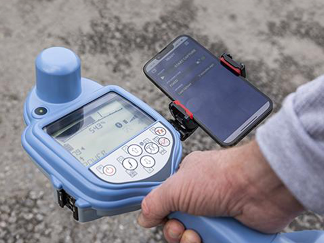
Locate and map buried utilities in a single operation.

Now, you have options to easily locate and map buried utilities with incredible precision, all in a single operation.
- Integrate mapping into utility locating procedures seamlessly.
- Incorporate utility locating into mapping procedures effortlessly.
- Unlock the flexibility to work with the system that best caters to your business needs.

Choose How You Want To Map
Upgrade to the new RD8200SG Survey Grade Locator
The RD8200SG is the most advanced locator that combines mapping and utility locating. With its unparalleled precision, users can now accurately map buried utilities with survey-grade accuracy.
The RD8200SG effortlessly integrates with your preferred system, empowering you to confidently handle the challenges of your work environment.
- Designed to effortlessly integrate with multiple mobile mapping applications, providing survey-grade accuracy with any third-party mapping apps you prefer.
- Works with Cansel’s Can-Net Virtual Reference Station (VRS) Network which gives users exceptional precision, fast initialization, and the largest coverage area in Canada.
- Use it with any widely compatible Android phone, tablet, or any existing device.
- It supports industry-standard file formats that you can use with your mapping software, making it easy to get started.
Plus!
- Achieve high-accuracy.
- Lightweight and ergonomic.
- Advanced rugged design to combat harsh weather conditions and temperatures.
- Engineered and built to the highest standards.


Radiodetection & Esri® Integration
COMING IN 2026: Radiodetection and Esri have partnered to unify underground utility locating and GIS. By connecting high-accuracy hardware directly with the ArcGIS platform, organizations can now capture, map, and sync field-verified utility data in a single, seamless workflow.
A Unified Workflow for Smarter Decisions
The integration eliminates the need to treat locating and mapping as separate steps. Using the RD8200SG, field crews can stream precise positions directly into ArcGIS Field Maps via Bluetooth, removing the manual data transfer and post-processing steps that traditionally slow down utility mapping.
-
Capture & Pair
Link precise underground utility locations with survey-grade GNSS positioning instantly. -
Direct Sync
Upload locate points directly to Esri feature layers, ensuring ArcGIS Online or Enterprise reflects near-real-time field updates. -
Single Interface
Use Field Maps to view existing GIS data, capture new positions, and update metadata—all while the locator is in hand.
Why This Integration Matters
Moving from a traditional "Locate → Paint → Paper Notes" cycle to a digital-first workflow delivers significant operational advantages:
Benefit |
Impact |
| Data Integrity | Higher confidence in utility records with "survey-grade" field verification. |
| Efficiency | Faster data handoff between field and office by eliminating re-work and digitization. |
| Risk Mitigation | Reduced utility strikes through precise, authoritative asset datasets. |
| Strategic Planning | Improved compliance and more accurate data for asset management and capital planning. |
Industry-Specific Impact
-
Municipalities
Build and maintain authoritative as-built records to support infrastructure planning. -
Utilities
Standardize locate data across all crews and feed accurate information into enterprise GIS. -
Contractors & Engineers
Deliver GIS-ready data to owners, reducing disputes and supporting SUE (Subsurface Utility Engineering) workflows.
Discover how Esri integration can enhance your data intelligence to drive smarter decisions from every locate.

Don't need a new locator?
Integrate mobile mapping technology features to your current locator
Utilize the Trimble Catalyst DA2 GNSS Receiver Kit V2, to obtain high-accuracy positions in more locations.
- The DA2 provides Trimble precision and position quality to any location-enabled workflow, ensuring increased accuracy and reliability.
Incorporate positional data into your survey measurements.
- Combine Trimble Catalyst and the DA2 GNSS Receiver to access precise positioning workflows on your Android or iOS device. Map assets at high-accurate levels all from any location-enabled app.
Create detailed maps in real-time.
- TerraFlow is the ultimate choice for utility mapping software in the industry today. Renowned for its unparalleled configurability and flexibility, TerraFlow integrates directly with high-accuracy GNSS (GPS) positioning systems and utility locate sets by Radiodetection. Its one-click mapping technology captures all spatial information simultaneously, streamlining process while improving accuracy.
