
Boundary Survey Cost Breaking Down Fees and Factors
When it comes to understanding the costs associated with boundary surveys, many property owners find themselves navigating a maze of fees and factors.
Whether you're buying a new home, planning a development, or simply curious about your property's limits, knowing what influences these costs can save you both time and money. From the type and size of your property to its location and the level of detail required, each element plays a crucial role in determining the final price.
In this article, we'll break down the various components that contribute to boundary survey costs, helping you make informed decisions for your land.
What is a Boundary Survey?
A boundary survey is a precise process conducted by professional surveyors to determine the exact property lines of a parcel of land. This survey is essential for identifying and mapping the legal boundaries, ensuring clarity in ownership, and preventing disputes between neighbors. It involves extensive research of historical records, legal documents, and includes physical markers on the property.
The primary goal is to provide an accurate representation of the property's limits, which is crucial for real estate transactions, land development, and legal proceedings. By clarifying the spatial extent of ownership, boundary surveys help protect property rights and facilitate informed decision-making regarding land use and management.
Why is a Boundary Survey Important?
A boundary survey is crucial for establishing clear property lines, which helps prevent legal disputes between landowners. It ensures accurate property valuation by defining the exact dimensions and area of the land. This precision is vital for real estate transactions, as it provides buyers and sellers with confidence in the property's boundaries.
Additionally, a boundary survey supports future development by offering a reliable framework for planning and construction. By clarifying ownership limits, it protects property rights and facilitates informed decisions regarding land use and management, ultimately contributing to a more organized and harmonious community.
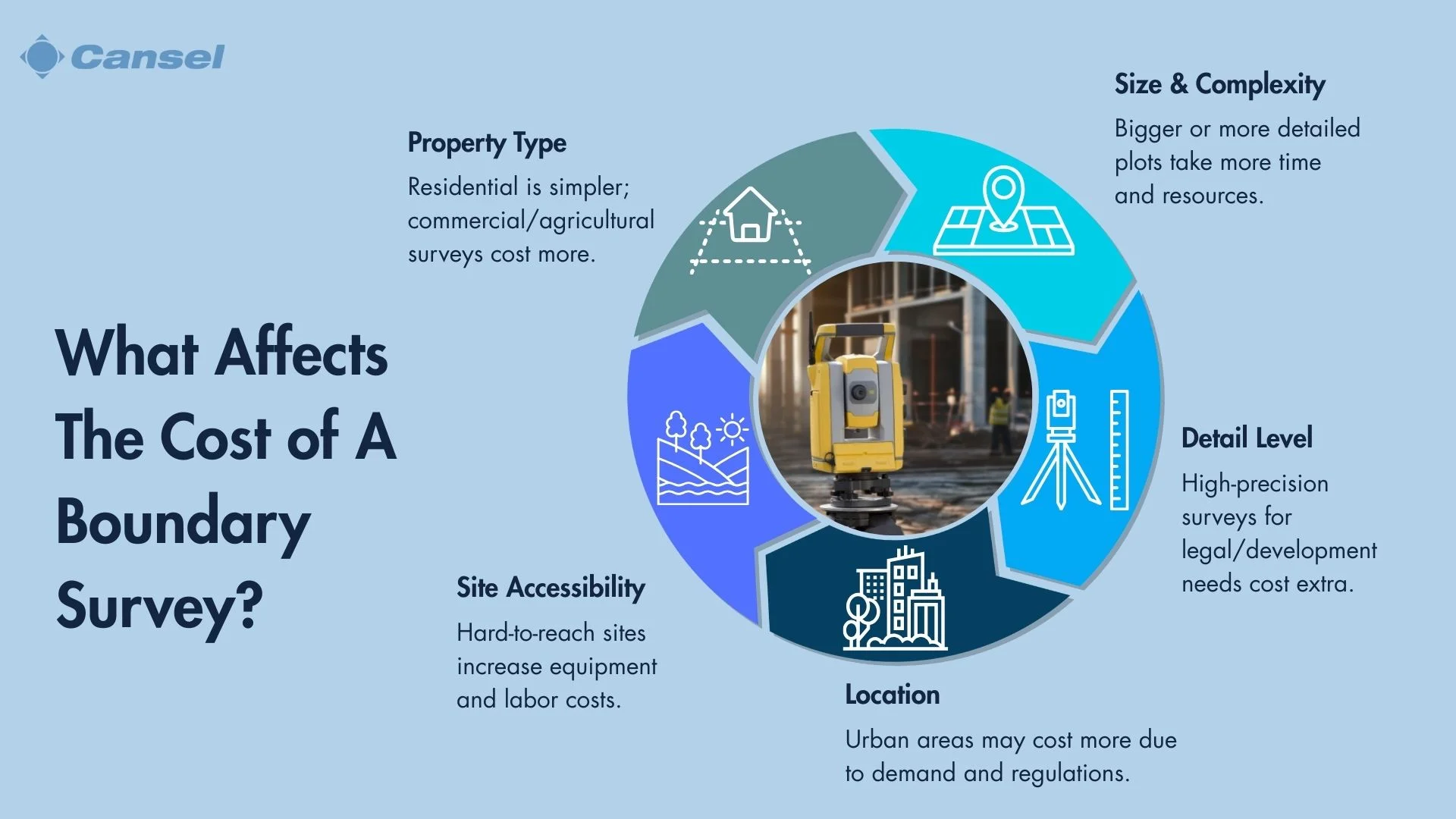
What Factors Influence the Cost of a Boundary Survey?
The cost of a boundary survey is influenced by several key factors. The type of property—whether residential, commercial, or agricultural—can significantly affect pricing. The size and complexity of the land also play a crucial role, as larger and more intricate plots require more time and resources to survey.
Geographic location impacts costs due to variations in regional pricing and local regulations. The accessibility of the site is another consideration, as remote or difficult-to-access areas may incur higher fees. Finally, the required level of detail in the survey can increase costs, especially if high precision is necessary for legal or developmental purposes.
Understanding these factors helps in estimating and managing the expenses associated with a boundary survey.
Types of Properties
The type of property, whether residential, commercial, or agricultural, directly influences the cost of a boundary survey. Residential properties often have simpler boundaries, while commercial and agricultural lands may involve more complex legal and physical delineations.
Size and Complexity of the Land
The size and complexity of the land significantly impact survey costs. Larger parcels require more time to survey, and intricate landscapes with varied terrain or numerous structures demand additional resources and expertise.
Geographic Location
Geographic location affects survey costs due to regional pricing differences and local regulatory requirements. Urban areas may have higher fees due to increased demand and stricter regulations, while rural areas might present logistical challenges that raise costs.
Accessibility of the Site
The accessibility of the site plays a crucial role in determining survey expenses. Remote or difficult-to-reach locations can increase costs due to the need for specialized equipment or additional personnel to conduct the survey effectively. For example, a drone like the the DJI Mavic 3 E Enterprise may be effective for fast mapping in more restricted areas.
Required Level of Detail
The required level of detail in a boundary survey can elevate costs, especially when high precision is necessary for legal disputes or development projects. Detailed surveys demand more time, advanced technology, and skilled surveyors to ensure accuracy and compliance.
How Do Surveyor Qualifications Affect Cost?
Surveyor qualifications significantly influence the cost of a boundary survey. Highly qualified surveyors, with extensive experience and advanced certifications, often command higher fees due to their expertise and ability to deliver precise results. Their in-depth knowledge and proficiency in using advanced surveying technologies ensure high-quality outcomes, which can be crucial for complex projects or legal requirements.
While hiring a more experienced surveyor may increase initial costs, it can prevent costly errors and disputes in the future, offering long-term value and peace of mind.
What Are Typical Fee Structures for Boundary Surveys?
Boundary surveys typically use various fee structures to accommodate different project needs. A flat rate is common for straightforward surveys, providing a fixed cost that covers all necessary services. An hourly rate is often applied to more complex projects, where the time required can vary significantly based on the site's intricacies.
The per acre rate is used for large properties, scaling the cost according to the land's size. Each structure offers unique benefits, allowing clients to choose the most suitable option based on their project's complexity and budget considerations.
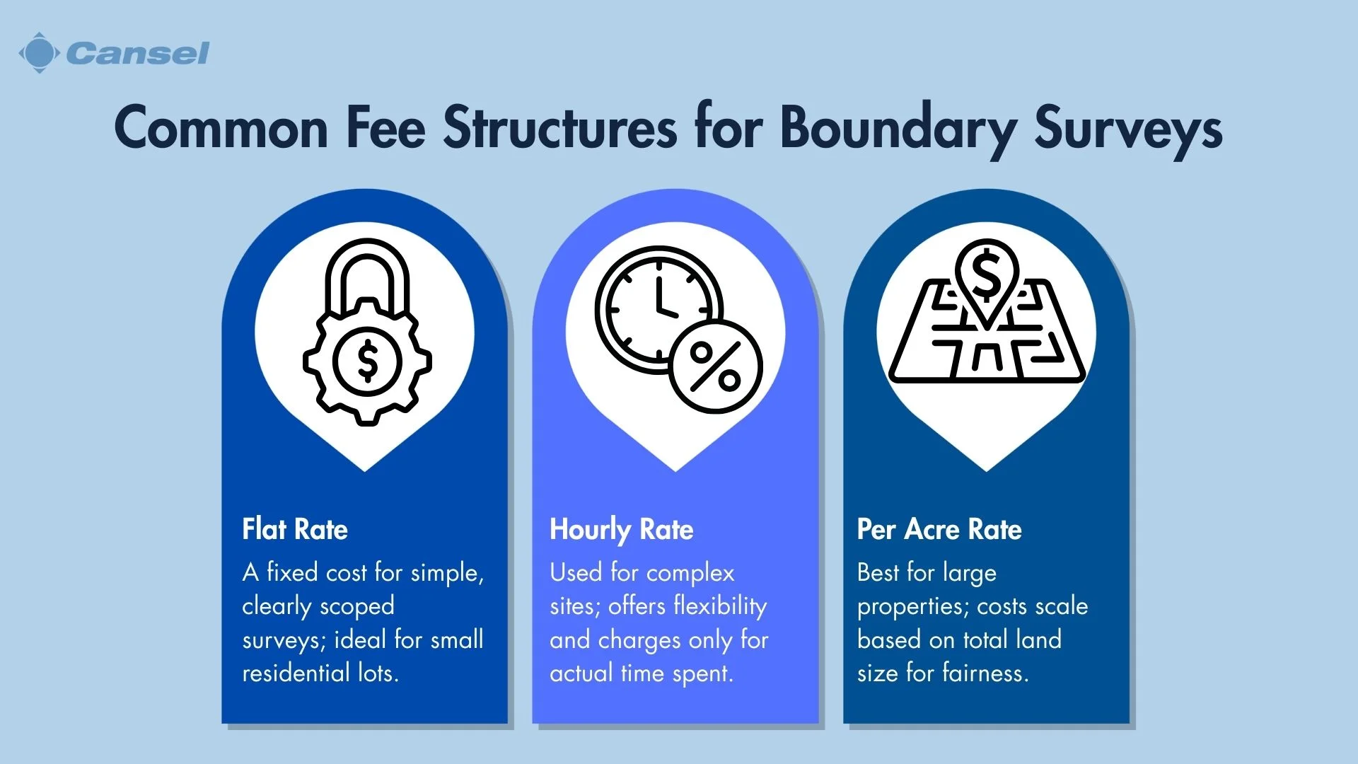
Flat Rate
A flat rate fee structure is often used for straightforward boundary surveys, providing a fixed cost that covers all necessary services. This approach offers predictability and simplicity, making it ideal for projects where the scope is well-defined and unlikely to change.
Hourly Rate
An hourly rate is typically applied to more complex surveying projects. This structure accounts for the variable time required to address the intricacies of the site. It provides flexibility, allowing the surveyor to adapt to unforeseen challenges while ensuring that the client only pays for the actual time spent on the survey.
Per Acre Rate
The per acre rate is used for surveying large properties, scaling the cost according to the land's size. This structure ensures that the pricing is proportional to the area surveyed, making it a fair and transparent option for extensive parcels of land. It allows clients to estimate costs more accurately based on the total acreage involved.
How Can One Estimate the Cost of a Boundary Survey?
Estimating the cost of a boundary survey involves considering several key factors. Begin by assessing the type and size of the property, as these directly influence the scope of work required. Evaluate the complexity of the land, including terrain and existing structures, which can affect the survey's duration and difficulty.
Geographic location plays a role, as regional pricing and local regulations may impact costs. Additionally, consider the required level of detail for the survey, as higher precision demands more resources. Consulting with multiple surveyors for quotes and comparing their qualifications and fee structures can provide a clearer picture of potential expenses.
What Are Potential Additional Costs?
In a boundary survey, potential additional costs can arise from various sources. Legal fees may be incurred if disputes over property lines require resolution through legal channels. Permits for land use might be necessary, depending on local regulations and the intended use of the surveyed land.
Additional surveying services, such as topographic surveys or environmental assessments, can also add to the overall expense. These extra costs are often project-specific and should be considered when budgeting for a boundary survey to ensure comprehensive financial planning.
Legal Fees for Disputes
Legal fees can become a significant additional cost if a boundary survey reveals disputes over property lines. Resolving these issues through legal channels may require hiring attorneys and potentially engaging in lengthy legal proceedings, which can increase overall expenses.
Permits for Land Use
Obtaining permits for land use is often necessary, especially if the surveyed land is intended for development or changes in usage. These permits can incur additional costs and may vary depending on local regulations and the specific requirements of the project.
Additional Surveying Services
Additional surveying services, such as topographic surveys or environmental assessments, can add to the total cost of a boundary survey. These services provide more detailed information about the land, which can be crucial for planning and development but also increase the financial outlay.
How Can One Reduce Survey Costs?
Reducing the cost of a boundary survey involves strategic planning and informed decision-making. Start by obtaining multiple quotes from qualified surveyors to ensure competitive pricing. Clearly define the scope of the survey to avoid unnecessary services and expenses.
Consider the timing of the survey, as scheduling during off-peak seasons might offer cost savings. Utilize any existing property documents or previous surveys to streamline the process. Additionally, opting for a surveyor who uses advanced technology, such as GPS or drones, can enhance efficiency and potentially lower costs by reducing time spent on-site; for example, the Trimble R980 allows surveyors to supports the Trimble Internet Base Station Service (IBSS) for streaming RTK corrections using Trimble Access field software for connected workflows.
What Should One Consider When Choosing a Surveyor?
When choosing a surveyor, consider several critical factors to ensure quality and reliability. Evaluate the experience and reputation of the surveyor, as seasoned professionals are more likely to provide accurate and efficient services. Verify their licensing and certification to ensure compliance with industry standards and legal requirements.
Review client testimonials and reviews to gauge customer satisfaction and the surveyor's track record. Don’t forget to assess their familiarity with local regulations and their use of advanced technologies, which can enhance the precision and speed of the survey. These considerations help in selecting a surveyor who meets your specific needs and budget.
Experience and Reputation
When selecting a surveyor, the experience and reputation of the professional are crucial. Experienced surveyors bring a wealth of knowledge and expertise, ensuring accurate and efficient results. A strong reputation often reflects a history of successful projects and satisfied clients, providing confidence in their abilities.
Licensing and Certification
Licensing and certification are essential factors to consider when choosing a surveyor. These credentials confirm that the surveyor meets industry standards and adheres to legal requirements, ensuring the quality and legitimacy of their work. Always verify that the surveyor holds the necessary certifications for your specific project.
Client Reviews and Testimonials
Reviewing client reviews and testimonials offers valuable insights into a surveyor's performance and customer satisfaction. Positive feedback from previous clients can indicate reliability and professionalism, while negative reviews may highlight potential issues. This information helps in making an informed decision when selecting a surveyor.
What Are Common Misconceptions About Costs?
Common misconceptions about the costs of boundary surveys often stem from a lack of understanding of the factors involved. One misconception is that all surveys are priced the same, regardless of property size or complexity, leading to unrealistic expectations. Another is the belief that hiring the cheapest surveyor will save money, without considering the potential for errors and additional costs due to inexperience or lack of proper equipment.
Some people also assume that advanced technology always increases costs, not realizing that it can improve efficiency and accuracy, ultimately saving money. Understanding these misconceptions helps in making informed decisions and setting realistic budgets for boundary surveys..
How Do Costs Vary by Region?
The costs of boundary surveys can vary significantly by region due to several factors. In urban areas, higher demand and increased complexity of properties often lead to elevated prices compared to rural locations. Additionally, regional differences in regulatory requirements and local market conditions can influence pricing.
Province-specific regulations may necessitate additional permits or specialized services, impacting overall costs. Understanding these regional variations is essential for accurate budgeting and planning, ensuring that property owners are prepared for the financial implications of conducting a boundary survey in their specific area.
Urban vs. Rural Areas
In boundary surveys, costs can differ significantly between urban and rural areas. Urban regions often have higher prices due to increased demand and the complexity of navigating densely built environments. The intricacies of urban infrastructure, such as underground utilities and closely packed properties, can add to the survey's complexity and cost.
Conversely, rural areas may offer lower costs, but the surveyor might face challenges like difficult terrain or larger property sizes, which can also impact pricing.
Province-Specific Regulations
Province-specific regulations can greatly affect the cost of boundary surveys. Different states may have unique legal requirements, such as additional permits or specific documentation, which can increase the overall expense.
Understanding these regulations is crucial for accurate budgeting and compliance, as failing to meet provincial requirements can lead to legal issues or additional costs down the line. Familiarity with local laws ensures that the survey is conducted efficiently and within legal parameters.
What Are the Long-Term Benefits?
Investing in a boundary survey offers several long-term benefits that extend beyond immediate property delineation. Establishing precise property lines helps prevent legal disputes with neighbors, safeguards property rights and avoids costly litigation. Accurate surveys contribute to property valuation, ensuring that real estate transactions reflect true land value.
This precision is also crucial for facilitating future development, providing a reliable foundation for planning and construction projects. Overall, a boundary survey enhances property management, promoting informed decision-making and long-term investment security.
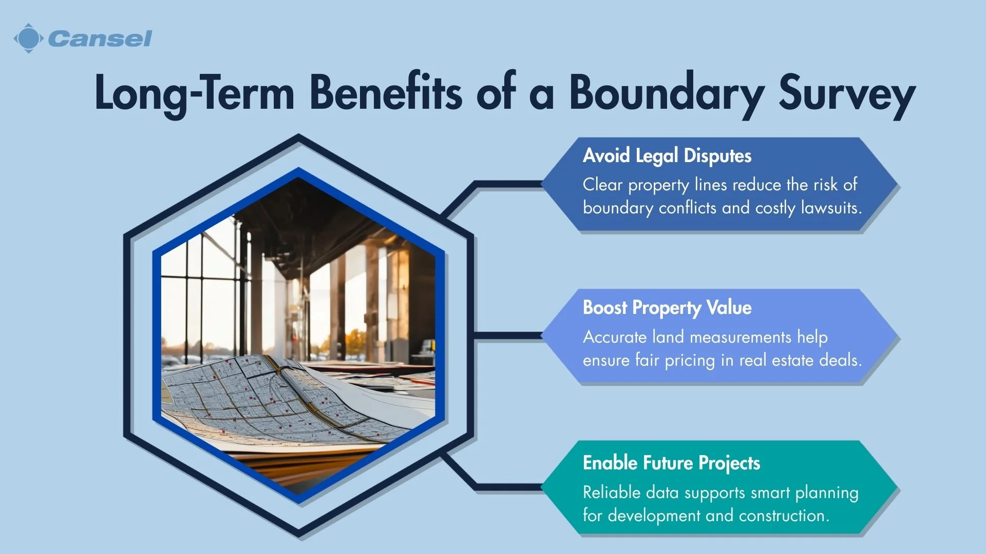
Preventing Legal Disputes
A boundary survey plays a crucial role in preventing legal disputes by clearly defining property lines. This clarity helps avoid conflicts with neighbors over land ownership, reducing the risk of costly and time-consuming litigation. By establishing precise boundaries, property owners can confidently manage and utilize their land without fear of encroachment issues.
Accurate Property Valuation
Accurate property valuation is another significant benefit of conducting a boundary survey. By providing detailed information about the property's dimensions and boundaries, surveys ensure that real estate transactions reflect the true value of the land. This accuracy is essential for both buyers and sellers, facilitating fair negotiations and informed decision-making.
Facilitating Future Development
A boundary survey is instrumental in facilitating future development. It provides a reliable foundation for planning and construction projects by offering precise measurements and data. This information is crucial for architects, engineers, and developers, enabling them to design and execute projects with confidence, ensuring compliance with zoning laws and maximizing land use potential.